

You can find on this page the Cyprus geographical map to print and to download in PDF. The Cyprus geographic map presents the topography, elevation, rivers, mountains, climate and physical features of Cyprus in Southern Europe.
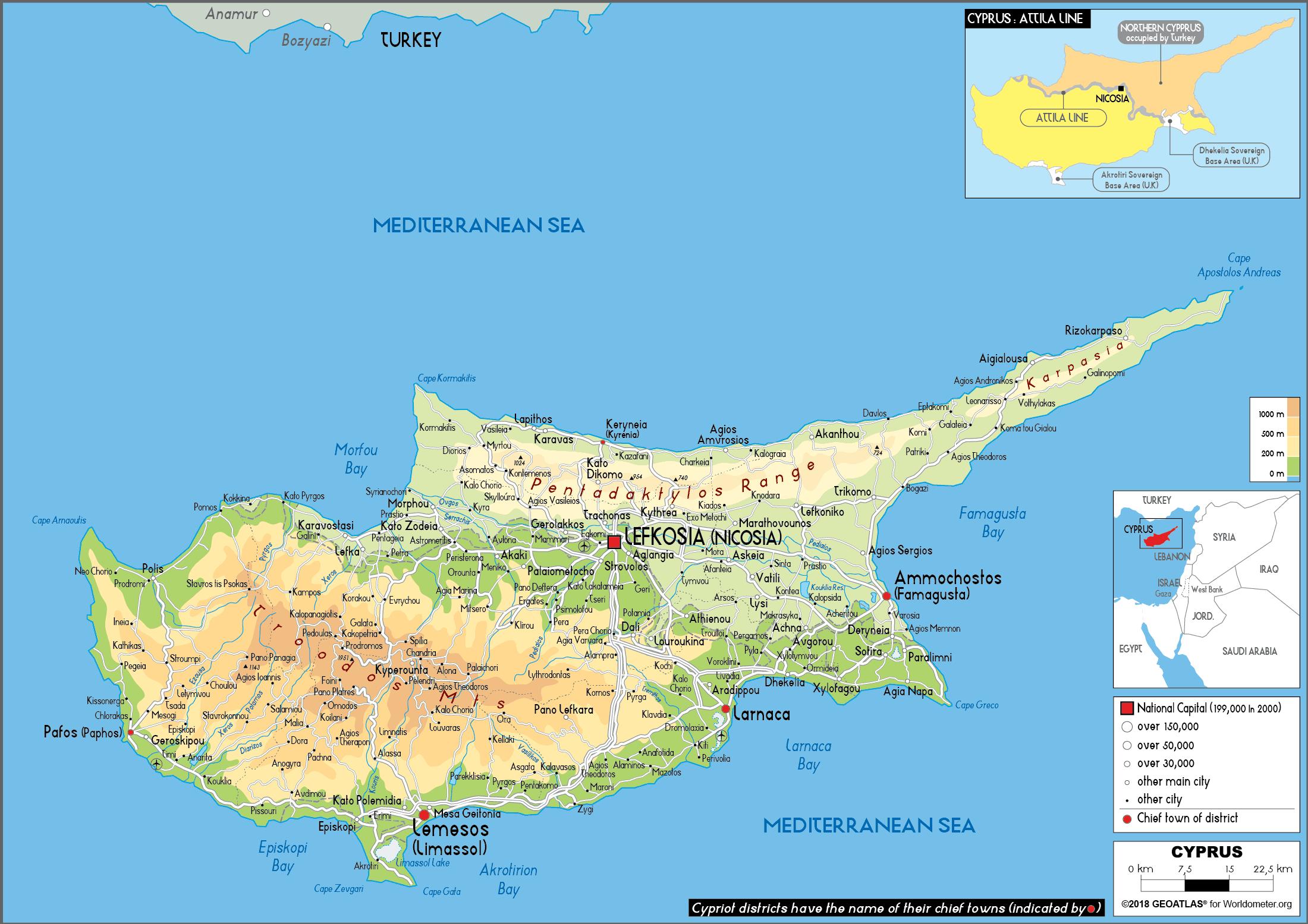
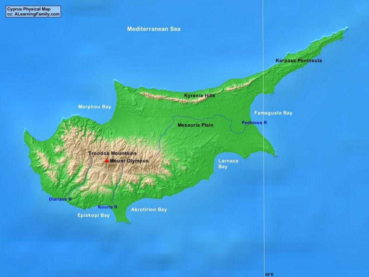
The Cyprus physical map shows landform and geography of Cyprus. This geographical map of Cyprus will allow you to discover physical features of Cyprus in Southern Europe. The Cyprus physical map is downloadable in PDF, printable and free.
Cyprus island is dominated by two mountain ranges, the Troodos Mountains and the Kyrenia Mountains, and the central plain, the Mesaoria, which is between them as you can see in Cyprus physical map. The Troodos Mountains cover most of the southern and western portions of the island and account for roughly half its area. The narrow Kyrenia Range, extends along the northern coastline. It is not as high as the Troodos Mountains, and it occupies substantially less area. The two mountain ranges run generally parallel to the Taurus Mountains on the Turkish mainland, the outlines of which are visible from northern Cyprus. Coastal lowlands, varying in width, surround the island. Geopolitically, the island is divided into four main segments. The Republic of Cyprus, the internationally recognized government, occupies the southern two-thirds of the island. The Turkish Republic of Northern Cyprus, recognized only by Turkey, occupies the northern one-third of the island. The United Nations-controlled Green Line is a buffer zone that separates the two. Lastly, two bases under British sovereignty, Akrotiri and Dhekelia, are located on the island.
The island of Cyprus is of volcanic origin. That is why there are a lot of low mountains and hills as its shown in Cyprus physical map. The unique shapes of the island formed a major mountain range, which is located in the North-East and can be seen from afar. Physical landscapes of Southern Cyprus and the eastern coast of the island are famous for its long sandy coasts. On the North the coast of the island is extremely rocky with numerous coves. Upon landing, visitors can enjoy the amazing views of the coves and bays in whimsical forms as well as green valleys surrounded by rocky mountains. The main features of the Cypriot landscape are hilly fields, fertile plains, covered with vineyards and coniferous forests in the mountains. Almost parallel to each other along the island are two mountain ranges: Kyrenia which is to the North and Troodos Mountains which is to the South. Low mountains and hills cover almost half of the island along with plains that are planted with olive and carob trees, wheat, and grapes.
Deforestation over the centuries has damaged the island of Cyprus drainage system and made access to a year-round supply of water difficult. A network of winter rivers rises in the Troodos Mountains and flows out from them in all directions. The Yialias River and the Pedhieos River flow eastward across the Mesaoria into Famagusta Bay; the Serraghis River flows northwest through the Morphou plain as its mentioned in Cyprus physical map. All of the island rivers, however, are dry in the summer. An extensive system of dams and waterways has been constructed to bring water to farming areas. The Mesaoria is the agricultural heartland of the island, but its productiveness for wheat and barley depends very much on winter rainfall; other crops are grown under irrigation. Little evidence remains that this broad, central plain, open to the sea at either end, was once covered with rich forests whose timber was coveted by ancient conquerors for their sailing vessels. The now-divided capital of the island, Nicosia, lies in the middle of this central plain.
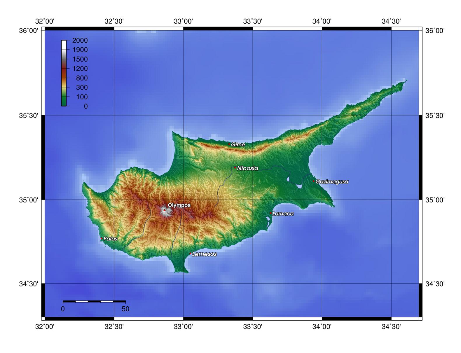
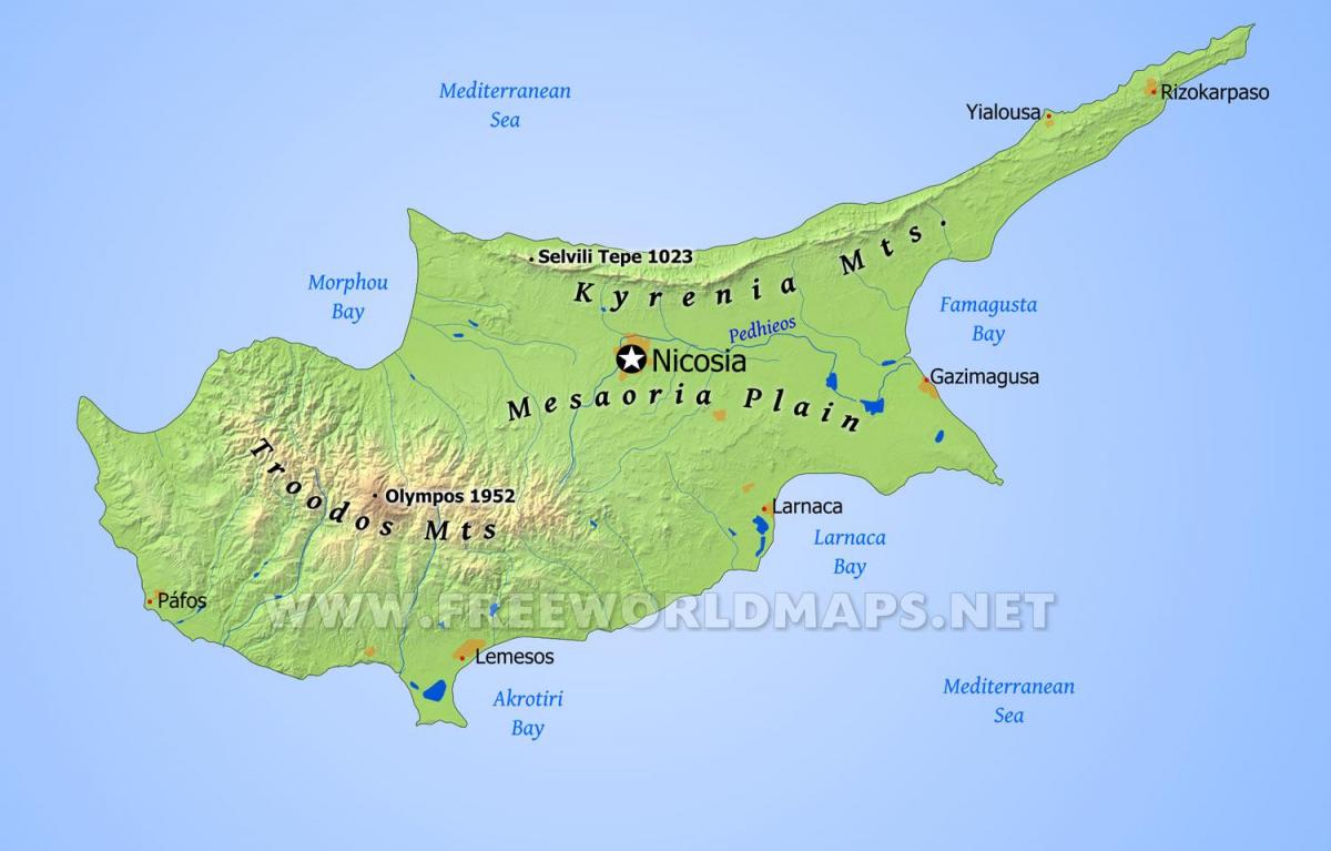
Cyprus topographic map shows the physical features of Cyprus. This topographical map of Cyprus will allow you to discover landforms and geographical of Cyprus in Southern Europe. The Cyprus topographic map is downloadable in PDF, printable and free.
The rugged Troodos Mountains, whose principal range stretches from Pomos Point in the northwest almost to Larnaca Bay on the east, are the single most conspicuous feature of the topographic landscape of Cyprus. Intensive uplifting and folding in the formative period left the area highly fragmented, so that subordinate ranges and spurs veer off at many angles, their slopes incised by steep-sided valleys. In the southwest, the mountains descend in a series of stepped foothills to the coastal plain. While the Troodos Mountains are a massif formed of molten igneous rock, the Kyrenia Range is a narrow limestone ridge that rises suddenly from the plains. Its easternmost extension becomes a series of foothills on the Karpass Peninsula as you can see in Cyprus topographic map. That peninsula points toward Asia Minor, to which Cyprus belongs geologically.
Even the highest peaks of the Kyrenia Range are hardly more than half the height of the great dome of the Troodos massif, Mount Olympus (1,952 m/6,404 ft) as its mentioned in Cyprus topographic map, but their seemingly inaccessible, jagged slopes make them considerably more spectacular. British writer Lawrence Durrell, in Bitter Lemons, wrote of the Troodos as "an unlovely jumble of crags and heavyweight rocks" and of the Kyrenia Range as belonging to "the world of Gothic Europe, its lofty crags studded with crusader castles." Rich copper deposits were discovered in antiquity on the slopes of the Troodos. The massive sulfide deposits formed as a part of an ophiolite complex at a spreading center under the Mediterranean Sea which was tectonically uplifted during the Pleistocene and emplaced in its current location.
Cyprus topographic map shows the three distinct geologic regions of the island. In the central and western part of the island is the Troodos Massif, a mountain range whose surface layer is mostly basaltic lava rock, and whose maximum elevation is 1,952 metres (6,404 ft). Running in a thin arc along the northeast margin of the island is Cyprus second mountain range, a limestone formation called the Kyrenia Range. The space between these ranges is home to the capital Nicosia, visible as a grayish-brown patch near the image center.

The Cyprus elevation map shows the different altitudes of Cyprus. This altitude map of Cyprus will allow you to know where are the highest and lowest regions of Cyprus in Southern Europe. The Cyprus elevation map is downloadable in PDF, printable and free.
The mountainous village of Lefkara is located in the Larnaca district and is separated into Pano (up) and Kato (down) Lefkara. The village is well-known around the world for its traditional embroidered lace, known as Lefkaritika, and its silver handicrafts. Lefkara is built at the foot of the south eastern side of the Troodos mountain range, 650 meters elevation above sea level and 3 kilometres from Larnaca as you can see in Cyprus elevation map. The village can be reached by following the A5, A1 and E105. The village of Agros is located 35 kilometers north of Limassol, at an altitude of around 1,100 meters above sea level. It is considered to be one of the most interesting mountainous villages in Cyprus and it is the principal village of the Pitsilias area, as it is located n the centre. Agros is well-known for its rose industry and for its other local products, such as, grapes and spoon sweets.
Go for a trip to the Cyprus mountains and discover how different the view of the island is from up there. The peaks of the Troodos mountains, which reach up to 2,000 metres elevation above sea level, provide an excellent panoramic view of all four corners of the island. It is the perfect place to cool down during the hot summer period but also a great get-away all year round. Troodos mountains are a very popular place to enjoy the mountain air and nature in all its splendour. The village of Omodos is situated 42 kilometres north-west of the city of Limassol, in the Krassohorion area. It is located near the western bank of the river Ha, at an average altitude of 810 metres as its shown in Cyprus elevation map. Omodos is surrounded by high mountain peaks and the highest of these peaks is Afamis at 1,153 metres and Kremmos of Laonas at 1,092 metres.
Olympos is the highest elevation point in Cyprus. As it is located in the southern (Greek) part of the island, which is independent, it is one of Europe country highpoints. At an elevation of 1952m it ensures that Cyprus is the fourth highest island of the Mediterranean (it is number three in size as well). Olympos is the culmination of the Troodos Range a huge dome which covers the south-western third of the island as its mentioned in Cyprus elevation map. With the ophiolite rocks like harzbugite and diurite, which you find close to the summit it is also a geological showcase. Here, at Cyprus the North-African and Anatolian tectonic Plates collide, which gave rise to the formation of the range (and island) in the first place. During the upheaval the ophiolite rocks of the earth crust rose to the surface and can now be studied near the summit of Olympos.

The rivers in Cyprus map shows the principal rivers with their names of Cyprus. The rivers map of Cyprus will allow you to find the main rivers which flow in and through Cyprus in Southern Europe. The Cyprus rivers map is downloadable in PDF, printable and free.
Most of the rivers in Cyprus flow for 3 to 4 months a year. The rest of the year most of them dry up. Exceptions are some parts of the Xeros, Diarizos, Kargotis, Marathasas, Kouris and Germasogeia rivers, which are at high altitude in the Troodos region and have a continuous flow as you can see in Cyprus rivers map. The largest rivers of the island come from the Troodos mountain range, which receives the greatest rainfall from all parts of Cyprus. Most rivers have a rather steep slope except the rivers in the lowlands along the southern coast of the island. However, most sections of the rivers are at an intermediate altitude. Based on data from the Department of Water Development, a study carried out in previous years shows that 31.5% of the river ecosystems in Cyprus were classified as good ecological status, 35.2% moderate, 7.4% incomplete and 1.4% poor ecological status. ¼ of them (24.5%) did not have sufficient data to categorize them.
Karkotis or Klarios river springs from Troodos and empties into Morphou Bay. It crosses the Solea Valley and its picturesque villages (Kakopetria, Evrychou, Kalliana etc). You can enjoy the sound, the fresh air and the beauties of the river by visiting the villages that offer many great spots to just sit and relax. Karkotis has a length of 23.6 kilometres as its shown in Cyprus rivers map. Diarizos is the fourth longest river in Cyprus, it covers a distance of 42 kilometres. Its sources are found on the slopes southeast of Kykkos, one next to Milikouri village and the other near Lemithou. Take a fascinating journey along the Diarizos River, through beautifully unspoiled green landscapes dotted with picturesque vineyards, where you will discover the lesser-known wine-producing region of the Diarizos Valley, located east of Paphos. Ezousa river springs from Stavros tis Psokas and empties into the dam of Kannaviou in Paphos. The river has carved the beautiful valley of Ezousa or the valley of Agia which is a protected area. It has a length of 41 kilometres.
Pedieos River, also spelled Pedieas, Greek Pediaíos, Turkish Pediyas, river in central and eastern Cyprus. It rises in the Troodos range and flows in a northeasterly direction toward Nicosia, where it takes an easterly turn through the part of the central lowlands called the Mesaoria Plain toward Famagusta Bay. Although the longest (about 60 miles [100 km]) in Cyprus, the river is not navigable as its mentioned in Cyprus rivers map. Formerly emptying into the bay near the ancient city of Salamis, it now drains into irrigation reservoirs near Akhyritou and Kouklia, west of Famagusta. The 41.5 km long Asprokremmos or Xeropotamos river is the fifth river in Cyprus. It has a length of 41.5km. Ιs springs from Troodos and passes through the forest of Paphos Asprokremmos dam is the second largest dam in Cyprus. It is built at an altitude of about 100 metres above sea level and is located 16 km, east of the city of Paphos.
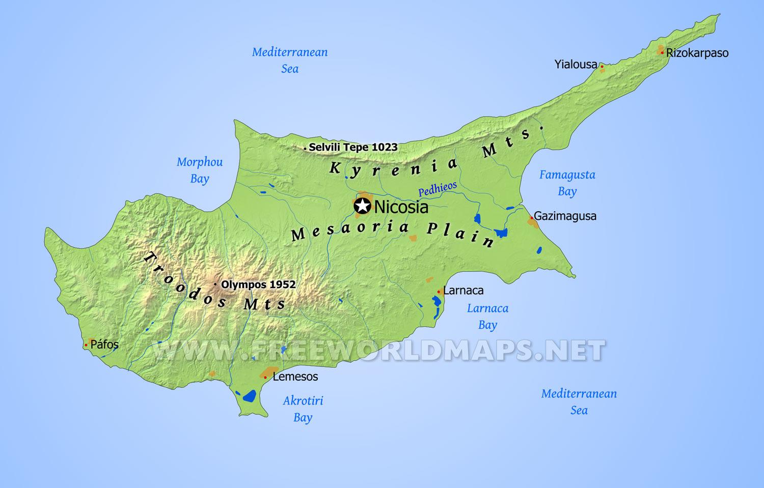
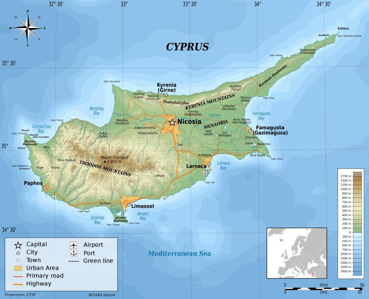
The mountains in Cyprus map shows the principal mountains with their names in Cyprus. The mountains map of Cyprus will allow you to find the main mountains ranges and highest mountains of Cyprus in Southern Europe. The Cyprus mountains map is downloadable in PDF, printable and free.
The landscape of Cyprus is best defined by the Troodos Mountain Range near the center of the island, easily recognizable on a satellite map by its vast expanse of green and rugged mountain peaks. The Troodos range is home to Mount Olympus in the district of Limassol, the tallest and most famous mountain of Cyprus. To the southwest of Troodos, the mountains give way to stepped foothills, eventually reaching coastal plains along Cyprus southwestern shore. Around the Troodos range is the circum Troodos sedimentary succession, massive outcrops of sediments that comprise most of Cyprus. In southwestern Cyprus are outcrops of volcanic, metamorphic, and sedimentary rock known as the Mamonia Complex, likely deposited between the Triassic and Cretaceous as you can see in Cyprus mountains map.
The other notable mountain range of Cyprus is the narrow Kyrenia Range, running along the northern border of the island until it reaches the Karpass Peninsula that juts out to the Levant, where the mountains become foothills. Its highest peak is Mount Selvili at 1,024m/3,360ft above sea level, and it is home to the Pentadaktylos or “five-fingered” peak, named for its resemblance to a hand as its shown in Cyprus mountains map. The Kyrenia Range of northern Cyprus is a sequence of sedimentary formations consisting largely of folds of Mesozoic limestone and, to a lesser extent, marble, created from a collision between the African and Eurasian plates.
Between Cyprus two mountain ranges is the Mesaoria, a vast, bare plain that occupies north-central Cyprus toward the east coast and Bay of Famagusta. Year-round freshwater is limited on the island, mainly supplied by winter rivers flowing out from the Troodos Mountains, which become dry during the summer, and by the winter rainfall. It has an area of approximately 1000 km² (390 mi²). It rises to an altitude of 325 m (1066 ft), with an average elevation of perhaps 100 m (330 ft) as its mentioned in Cyprus mountains map. There are a number of rivers and other water courses crossing this plain, but none of them have water year round. The word "Mesaoria" (sometimes spelled "Mesarya"), means "between the mountains" in Greek. For the most part, the Mesaoria is a flat, bare plain, with few trees except for those planted as windbreaks.

The Cyprus climate map shows average temperature and climate zones of Cyprus. This climate map of Cyprus will allow you to know weather, average precipitation, average sunshine and different climates of Cyprus in Southern Europe. The Cyprus climate map is downloadable in PDF, printable and free.
Cyprus has a subtropical climate – Mediterranean and Semi-arid type (in the north-eastern part of island) – according to Köppen climate classification signes Csa and Bsh, with very mild winters (on the coast) and warm to hot summers. Snow is possible only in the Troodos Mountains in the central part of island. Rain occurs mainly in winter, with summer being generally dry. Cyprus has the warmest climate (and warmest winters) in the Mediterranean part of the European Union.[citation needed] The average annual temperature on the coast is around 24 °C (75 °F) during the day and 14 °C (57 °F) at night as you can see in Cyprus climate map. Generally – summer/holiday season lasts about 8 months, begins in April with average temperatures of 21–23 °C (70–73 °F) during the day and 11–13 °C (52–55 °F) at night, ends in November with average temperatures of 22–23 °C (72–73 °F) during the day and 12–14 °C (54–57 °F) at night, although also in remaining 4 months temperatures sometimes exceeds 20 °C (68 °F).
Among all cities in the Mediterranean part of the European Union, Limassol has the warmest winters, in the period January–February average temperature is 17–18 °C (63–64 °F) during the day and 8–9 °C (46–48 °F) at night, in other coastal locations in Cyprus is generally 16–17 °C (61–63 °F) during the day and 7–9 °C (45–48 °F) at night. In March and December in Limassol average temperatures is 19–20 °C (66–68 °F) during the day and 10–11 °C (50–52 °F) at night, in other coastal locations in Cyprus is generally 17–19 °C (63–66 °F) during the day and 8–11 °C (46–52 °F) at night as its shown in Cyprus climate map. Middle of summer is hot – in July and August on the coast the average temperature is usually around 33 °C (91 °F) during the day and around 23 °C (73 °F) at night (inside the island, in the highlands average temperature exceeds 35 °C (95 °F)) while in the June and September on the coast the average temperature is usually around 30 °C (86 °F) during the day and around 20 °C (68 °F) at night. Large fluctuations in temperature are rare.
Temperatures inside the island are more stringent, with colder winters and more hot summers compared with the coast of the island. Average annual temperature of sea is 21–22 °C (70–72 °F), from 17 °C (63 °F) in February to 27–28 °C (81–82 °F) in August (depending on the location) as its mentioned in Cyprus climate map. In total 7 months – from May to November – the average sea temperature exceeds 20 °C (68 °F). Sunshine hours on the coast is around 3,400 per year, from average 5–6 hours of sunshine / day in December to average 12–13 hours in July. This is about double that of cities in the northern half of Europe, for comparison: London – 1,461, however in winter up to some times more sunshine, for comparison: London has 37 hours while coastal locations in Cyprus has around 180 hours of sunshine in December (that is, as much as in May in London).