

You can find on this page the Cyprus trains map to print and to download in PDF. The Cyprus railways map presents the rail network and shows high speed rails routes of Cyprus in Southern Europe.

The Cyprus rail map shows all the railway stations and lines of Cyprus trains. This train map of Cyprus will allow you to easily travel by train in showing the major rail routes and high speed rail routes of Cyprus in Southern Europe. The Cyprus rail map is downloadable in PDF, printable and free.
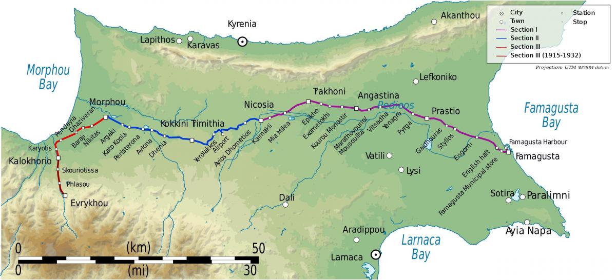
The Cyprus Government Railway used to operate from October 1905 to December 1951. It had a total length of 122 km and 39 stations, stops and halts as you can see in Cyprus rail map. It was closed down due to financial reasons. An extension of the railway which was built to serve the Cyprus Mines Corporation in Skouriotissa operated until 1974. Troodos mountain communities are attempting to revive the old Skouriottisa-Evrychou railway, as a tourist attraction and for the transportation of locals, Evrychou community leader Xenofon Xenofontos, told in-cyprus. The idea which started from the community of Evrychou has received the “green light from the government” and is already in the first phase of the process, Xenofontos said. The train line will start from Evrychou central station (where the Cyprus railway museum is located) and will stop at the villages of Katydata, Korakou, Flasou and Linou.
Rail financing of £ 127,468 (Pound) was provided by a loan under the Colonial Loans Act of 1899, and the line was basically built by a subcontractor contract. The total length of the line is 76mil (122 km), the rail span is 2 feet 6 inches (76,2 cm) as its shown in Cyprus rail map. There were pedestrians at four main stations. The slope of the line was 100 in 1 between Famagusta Nicosia and 60 in 1 between Nicosia Omorfo. There were about 30 stations along the line, especially Evrihu, Omorfo (Güzelyurt), Nicosia and Famagusta. Station names were written in Turkish (Ottoman Turkish), Greek and English. Some of these stations were also used as post and telegraph agencies. The train took the distance between Nicosia and Famagusta in about 30 hours, with an average speed of 48 mph (approx. 2 km / h). The travel time of the whole line was 4 hours.
The railway network was used for various operations, including for passenger travel, with stations located every two miles along the route, with signs in Turkish, Greek and English. There were only two trains per day for passenger use, one in the morning and one in the evening. The government also used the railway for transporting mail, carrying timber from the Troodos Mountains and freight from Famagusta port as its mentioned in Cyprus rail map. The CMC used the railway for transporting freight, ore and minerals across Cyprus. Interestingly, some of the stations along the route also served as telephone exchanges and post offices / telegram offices as well as train stations. During both World Wars, the railway was also used to transport troops from Famagusta, Denizli (Xeros) and the airport. Throughout its amazing 46 year history, the Cyprus railway train line carried over 7 million passengers and 3 million tons of goods and minerals.