

You can find on this page the Cyprus region map to print and to download in PDF. The Cyprus political map presents states, regions, provinces and surrounding areas of Cyprus in Southern Europe.
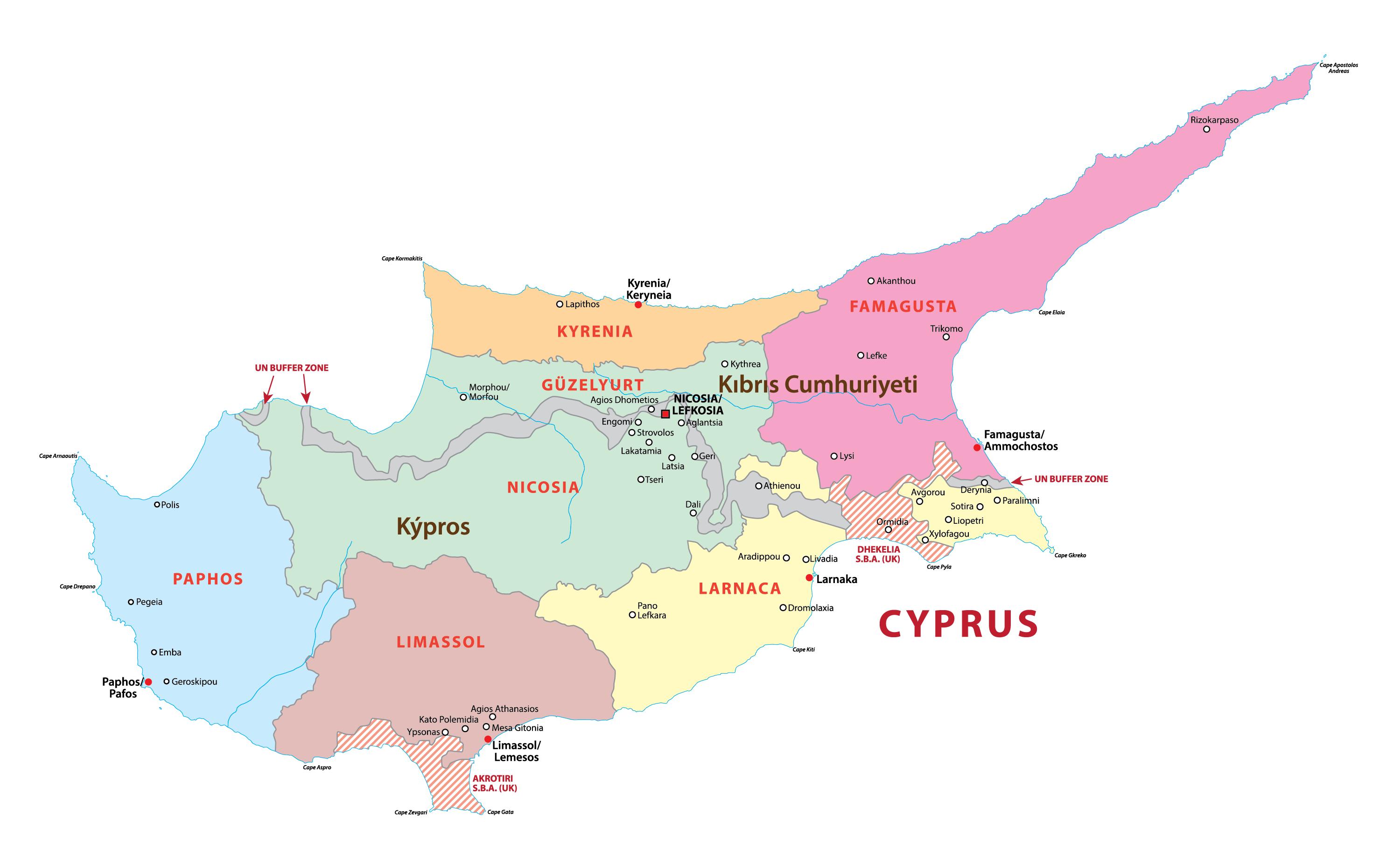
The Cyprus regions map shows surrounding areas and provinces of Cyprus. This administrative map of Cyprus will allow you to know regions of Cyprus in Southern Europe. The Cyprus regions map is downloadable in PDF, printable and free.
There are 6 districts within Cyprus with 2 districts overlapping the buffer zone as you can see in Cyprus regions map. Because of the UN Buffer Zone, Cyprus is filled with exclaves and abandoned areas like the disused international airport in the capital city of Nicosia. Each district capital shares the same name as the district. Next, districts are divided into municipalities and communities. The first region in Cyprus we are going to discuss is none other than Larnaca, otherwise known as Larnaka. The port city resides on the south coast of Cyprus and is the third largest city on the island. Its population is estimated at 72,000 with the weather regarded as a semi-arid climate meaning it holds lovely Mediterranean seasons. It is known for its high-rise ocean view apartments, bustling downtown center and a strong family community. The city has a variety of beautiful historical structures including St. Lazarus Church and Hala Sultan Tekke Mosque.
Nicosia, also known as Lefkosia, is the capital of Cyprus. This district in Cyprus holds a population of over 200,000 with a hot semi-arid climate; this means the regions temperate is slightly higher on average than Larnaca. The capital is the most southeastern EU member and has been inhabited for well over 4,000 years. Not only is it the capital of Cyprus but it is also the center of shopping, art galleries and museums as you can see in Cyprus regions map. Limassol is the second largest district after Nicosia and was named by TripAdvisor as the 3rd most up and coming destination in the world back in 2014, so it is definitely worth a visit now. The city weather is slightly different to that of Nicosia and Larnaca; Limassol has hot and dry summers with more mild winters, making it a subtropical Mediterranean climate. Limassol is well known for its marina, the cosmopolitan waterfront hub of the island. The marina hosts a mixture of luxury dining experiences with spectacular views along with elegant shops and relaxing fitness centers.
Out of all the regions in Cyprus, Paphos is undoubtedly the most famous among tourists. Also spelt Pafos, this district is located on the southwest coast of the island with a population of around 35,000 people as its shown in Cyprus regions map. UNESCO added the entire town of Paphos to its World Culture Heritage due to its abundance of treasures including the Tombs of the Kings and mosaics in the Houses of Dionysos. Ammochostos region also known as Famagusta and mirrors Paphos with its popularity amongst tourists. The area is made up of several small towns; Ayia Napa, Paralimni and Protaras, all of which are resort towns. This area is undeniably most famous for the golden sand beaches like Nissi Beach and Fig Tree Bay along with the vivid nightlife of Ayia Napa but there is much more to this district.
The Cyprus political map shows regions and provinces of Cyprus. This administrative map of Cyprus will allow you to show regions, administrative borders and cities of Cyprus in Southern Europe. The Cyprus political map is downloadable in PDF, printable and free.
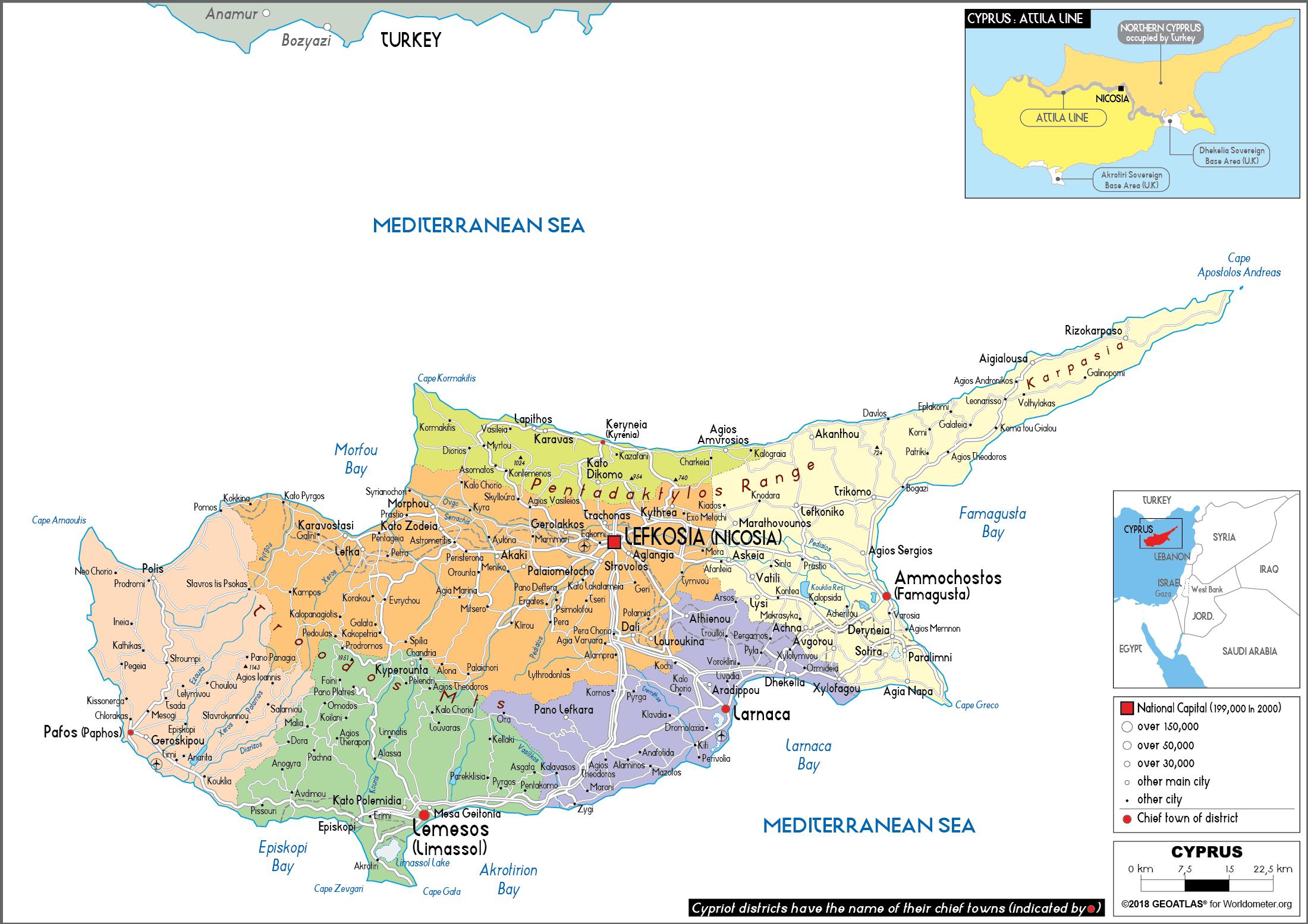
Politics of the Republic of Cyprus takes place in a framework of a presidential representative democratic republic, whereby the President of Cyprus is both head of state and head of government, and of a multi-party political system. Executive power is exercised by the government. Legislative power is vested in both the government and the House of Representatives. The Judiciary is independent of the executive and the legislature as you can see in Cyprus political map. Cyprus is a divided island. Since 1974, the internationally recognised Republic of Cyprus has controlled the south two thirds, and the Turkish Republic of Northern Cyprus the northern one-third. The Government of the Republic of Cyprus has continued as the sole internationally-recognized authority on the island (as well as the UK being internationally recognized with respect to the SBAs), though in practice its power extends only to the government controlled area.
The division of Cyprus has remained an intractable political problem plaguing relations between Greece and Turkey, and drawing in NATO, of which both Greece and Turkey are members, and latterly the European Union, which has admitted Greece and Cyprus and which Turkey has been seeking to join for over twenty years as its shown in Cyprus political map. The most recent developments on the island have included the reopening of the border between the two sides, and the failure of an attempt to reunify the island under the terms of a United Nations-sponsored initiative guided by the UN Secretary-General, Kofi Annan. None of the Greek Cypriot parties has been able to elect a president by itself or dominate the 56-seat House of Representatives. The 165,000 Greek Cypriot refugees are also a potent political force, along with the independent Orthodox Church of Cyprus, which has some influence in temporal as well as ecclesiastical matters.
The continued difficulties in finding a settlement presented a potential obstacle to Cypriot entry to the European Union, for which the government had applied in 1997. UN-sponsored talks between the Greek and Turkish leaders, Glafkos Klerides and Rauf Denktaş, continued intensively in 2002, but without resolution. Thus, limiting the number of Greek-Cypriots in the Turkish-Cypriot constituent unit, and preventing them from using their political rights in the north, appears to be a necessary territorial mechanism that would secure bi-zonality. In May 2004, Cyprus entered divided the EU, although in practice membership only applies to the southern part of the island which is in the control of the Republic of Cyprus. In acknowledgment of the Turkish Cypriot community support for reunification, however, the EU made it clear that trade concessions would be reached to stimulate economic growth in the north, and remains committed to reunification under acceptable terms as its mentioned in Cyprus political map. The 16 August 1960 constitution envisioned power sharing between the Greek Cypriots and Turkish Cypriots. Efforts to amends the constitution sparked the intercommunal strife in 1963.

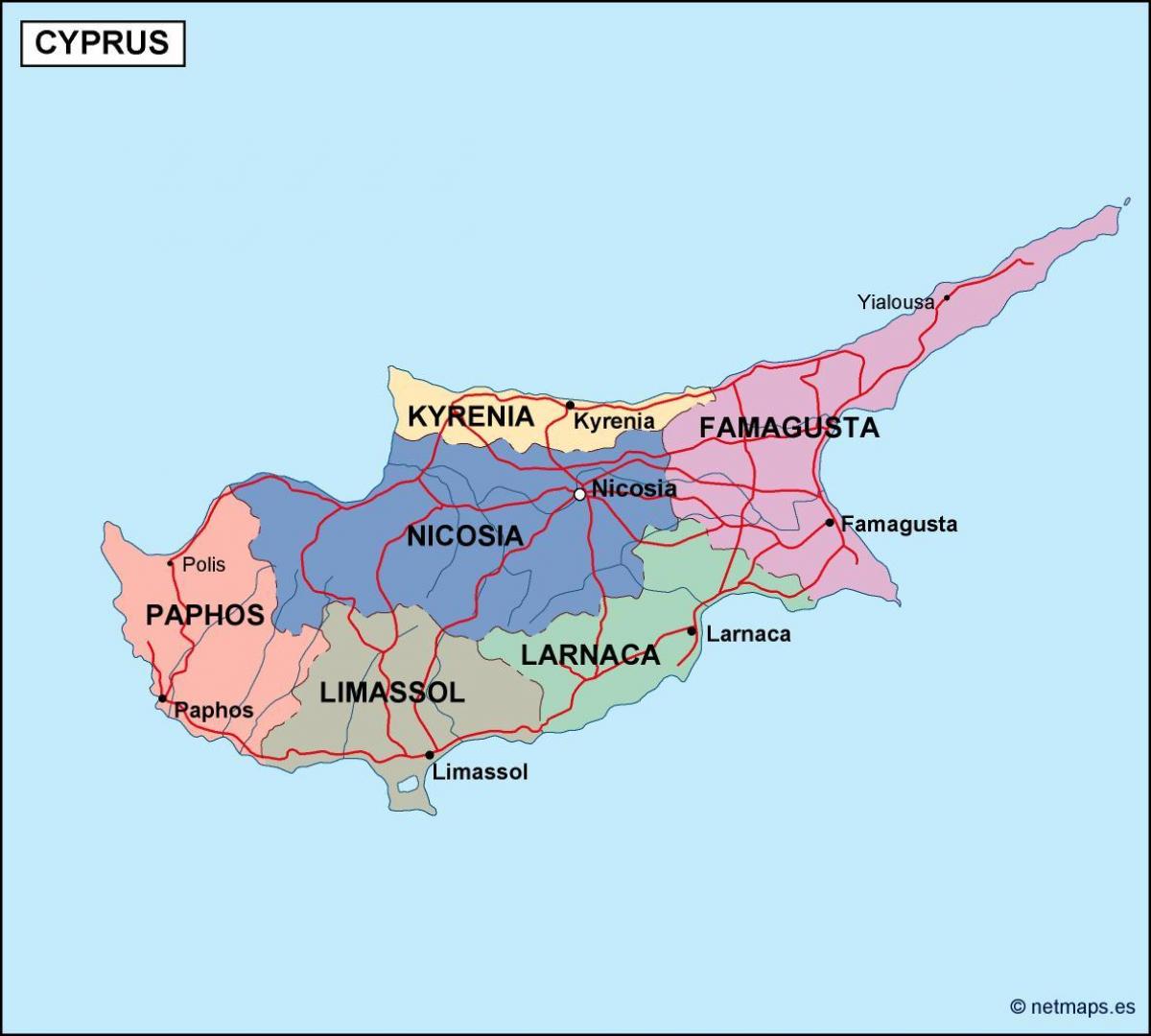
The Cyprus states map shows all departments and regions of Cyprus. States map of Cyprus will allow you to know areas and cities of Cyprus in Cyprus. The Cyprus states map is downloadable in PDF, printable and free.
Cyprus is divided into six administrative states. These are: Nicosia, Limassol, Pafos, Larnaka, (in the government-controlled areas) and Famagusta and Keryneia (in the occupied areas) as you can see in Cyprus states map. Each state is headed by a District Officer who is essentially the local representative or extended arm of the government. The state Officer acts as the chief-coordinator of the activities of all Ministries in the State. State Officers are answerable to the Ministry of the Interior, which is headed by a Permanent Secretary as chief administrator. These form a devolved level of the central government and will therefore be considered as intermediary level of government in the following study. Kyrenia, in the northernmost part of the country and a section of two other districts are located in “TRNC", the self-declared republic which is occupied territory with a government recognised only by Turkey. The District Officer is the chief coordinator and liaison officer for the activities of all the ministries in the district and is accountable to the Ministry of the Interior. He is a senior public servant and is appointed by the Public Service Commission.
Local autonomous self-administration, however, is recognised by the Constitution and by the Law for Municipalities (demos, plural demoi) and Communities (koinotita, plural koinotites). Both have mainly administrative competences. All in all, Cyprus has currently six States, thirty-nine Municipalities (in urban and touristic centres) and 478 Communities (in rural areas) as its shown in Cyprus states map. Of the thirty-nine Municipalities in Cyprus, nine are in the northern part of the island and, since 1974, have been displaced to the areas of the Republic of Cyprus which are under the effective control of the government. Since 2018, the government is attempting to reform the system of regional administration by introducing a new system of provincial clusters. The overall aim of the reform is to grant more competencies and funds to the regional and local authorities. The reform is structured around 3 themes. First, to cluster together the services that are provided by the communities. This would lead to a more efficient and cost-effective structure. Second, the integration of smaller municipalities within bigger ones. Third, the management of the water reserves, solid waste and of the sewage system by provincial councils.
The six states ensure the implementation of Central Government and Ministries that falls within the jurisdiction of central government in all Provinces. District officers are responsible for applying government policy at the district level and supervise the functioning of the communities. Cyprus states as its mentioned in Cyprus states map are as follows: Ammochostos (Famagusta); (all but a small part located in the Turkish Cypriot community), Keryneia (Kyrenia; the only district located entirely in the Turkish Cypriot community), Larnaka (Larnaca; with a small part located in the Turkish Cypriot community), Lefkosia (Nicosia; a small part administered by Turkish Cypriots), Lemesos (Limassol), Pafos (Paphos); note - the 5 "districts" of the "TRNC" are Gazimagusa (Famagusta), Girne (Kyrenia), Guzelyurt (Morphou), Iskele (Trikomo), Lefkosa (Nicosia).